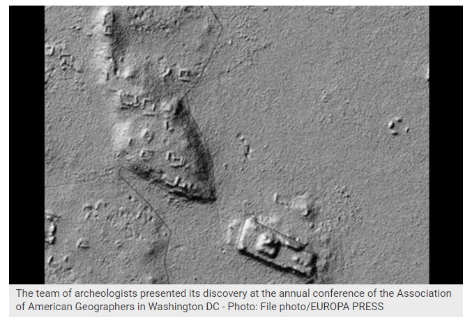
Under wetlands in southern Mexico, archeologists have found evidence of ancient Maya crop fields which were broadly used and constituted the base of a sophisticated market economy.
The Maya civilization was a Mesoamerican civilization developed by the Maya peoples in an area that encompasses southeastern Mexico, all of Guatemala, and Belize, as well as western portions of Honduras and El Salvador.
The most ancient evidence of the Maya civilization dates back to 1,800 B.C. However, most Maya cities flourished between the years 250 and 900 of our time.
When the Spanish arrived in the 1500s, some of the largest Maya cities were deserted. Nicholas Dunning, a professor at the University of Cincinnati, was part of a research team that found evidence of irregular shaped crop fields in Mexico, following water channels and rivers at a place called Laguna de Terminos in the Mexican Gulf.
The archeologists expect to find evidence of human settlements once excavations begin.
The team presented its discovery at the annual conference of the Association of American Geographers in Washington DC.

The extensive crop fields suggest that the ancient Mayas may have produced a harvest surplus, specially of cotton, which was used to make fabrics that were traded throughout Mesoamerica. “The Maya civilization had a much more complex market economy than is commonly believed,” said Dunning in a press release.
Satellite images revealed a patchwork near drainage ditches, which suggested they were man made. The archeologist also studied images of the region created by NASA through LIDAR technology, which allows to appreciate ground contours under the canopy of trees and vegetation. The revision confirmed Dunning’s suspicions: The area was once covered by ancient crop fields.
“It seemes that they were developed in a very simple way, through sewage modifications on the edge of the wetlands,” said Dunning. “They probably dug deeper and straightened some water channels or connected them to certain places. Later on, they expanded the fields with more complex water engineering.”
Dunning said that the ancient Mayas probably sold perishable products such as corn and cassava. They exchanged blankets and ornamented textile rolls made of the cotton they grew. These were largely appreciated by the Spanish in the 16th century.
LIDAR
What is it?
LIDAR is the optical analogue of RADAR (RAdio Detection And Ranging). The only thing that separates LIDAR from RADAR is the energy source. LIDAR’s source being a laser in the optical part of the electromagnetic spectrum. LIDARs are active remote sensors since they include the light source on which the measurement depends. They are used to measure things such as: range and altitude, atmospheric vertical profiles of aerosols and trace gas densities, temperature, cloud cover, wind velocity, shape and size of landscape features, height and density of forests, sea surface roughness.
Sources:
- El Universal
- NASA

