

Hurricane track forecast accuracy has improved since 1990, but there has been little improvement in intensity forecast accuracy. A new NASA mission using eight micro-satellites will make accurate measurements of ocean surface winds in and near the eye of the storm throughout the lifecycle of tropical cyclones, typhoons & hurricanes.
The Cyclone Global Navigation Satellite System (CYGNSS) will probe the inner core of hurricanes to learn about their rapid intensification. The mission will launch from Cape Canaveral Air Force Station, Florida, on a Pegasus XL rocket. The University of Michigan is developing CYGNSS.
NASA’s Cyclone Global Navigation Satellite System (CYGNSS) mission, is basically a constellation of eight microsatellites that will gather never-before-seen details on the formation and intensity of tropical cyclones and hurricanes.
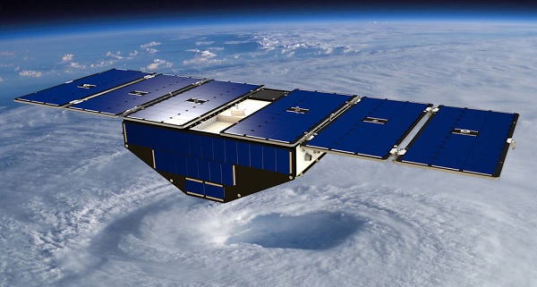
Concept of one of the eight Cyclone Global Navigation Satellite System satellites deployed in space above a hurricane (Photo: NASA.gov)
Technology has always progressed on waves of innovation. In the business of tropical system monitoring, a new set of satellites managed by NASA’s Langley Research Center in Hampton, Virginia, aims to ride a new wave of advanced weather prediction and storm tracking.
Previous space-borne instruments have been unable to accurately measure ocean surface winds in the inner core of hurricanes because their signals are degraded in regions of heavy precipitation. The Cyclone Global Navigation Satellite System (CYGNSS), a collection of eight low-cost, low-Earth orbiting microsatellite observatories that will travel to space on a single launch vehicle, is crafted to change that.
CYGNSS will measure surface winds in and near the inner core of tropical systems, including regions beneath the eyewall and intense inner rain-bands that could not previously be measured from space. The instrument will make the measurements using direct and reflecting signals from GPS satellites already in orbit.
For more information about CYGNSS go to: http://www.nasa.gov/cygnss
Source: nasa.gov